Search
I'm always surprised how poor legibility the most used digital map has
One shows only a few shops, often the ones that pay the most, the other shows the true number of different places in the area.
Is there any documentation on mapping individual small plants like flowers or cacti?
@openstreetmap Is there any documentation on mapping individual small plants like flowers or cacti? I'd like to start mapping botanical gardens but cannot find any information on this.
Das Atomium in #Brüssel, gerendert in #cgeo auf der 3D #OpenStreetMap #Freizeitkarte sieht lustig aus.
Das Atomium in #Brüssel, gerendert in #cgeo auf der 3D #OpenStreetMap #Freizeitkarte sieht lustig aus.
OSM: Where zoos look like zoos
Attached: 2 images Glad to see the great job @[email protected] and @[email protected] are doing. For cycling to the zoo's main entrance, where I can buy entry, they suggest a sensible route. #Google maps seems to suggest I go through the zoo, possibly via the tiger cage. #OSM #Op...
>Henry@[email protected] > > Glad to see the great job @openstreetmap and @organicmaps are doing. For cycling to the zoo's main entrance, where I can buy entry, they suggest a sensible route. #Google maps seems to suggest I go through the zoo, possibly via the tiger cage. > >https://social.lol/@hl/113047359789803891
>Dawid Rejowski@[email protected] > >@hl @openstreetmap @organicmaps > >Also somehow ZOO looks more like a ZOO. > >Here I needed a while to understand what is that place. Only after reading the labels I understood it is the center of Warsaw, a place that should be one of the most recognizable places in Poland.\ >Compared to OragnicMaps, with rich colors, colorful Metro icons, building shapes and rails, Google Maps looks very blended. > >https://101010.pl/@didek/113050389244877936
Can I use a Relation to join a restaurant and its patio?
I've got a patio for a restaurant tagged as leisure=outdoor_seating. That page says you can add operator=* as a string, but I'm wondering if I can add a Relation between the patio and the restaurant. This is really for semantic reasons, because if the restaurant changes its name or gets a new owner, it would be nice if the patio didn't then have out-of-date information.
I don't see a Relation type that's relevant. I don't want to just start doing my own thing, so does anyone know of a way to use a Relation here, and if not, is that something that can be proposed?
Thanks for all of the responses on my other questions, btw. This community has been very helpful.
What value should I use for traffic_signals=*?
I'm looking to tag a simple 4 way stop with typical US red/yellow/green traffic signals. I was wondering what the difference between signal and traffic_lights is in iD, and the wiki page just says this about traffic_lights:
> A typical traffic signal. This value was the second most common value as of 2021-09-15 despite being undocumented until that point.
Looking at the talk page there, it links to this post, where an iD dev seems rather annoyed at the wiki:
> I took a look at https://wiki.openstreetmap.org/wiki/Key:traffic_signals and now I'm furious. > > Forget it. > > There is no way I'm going to support traffic_signals=yes for pedestrian signals, after the wiki folks aren't even ok with iD using traffic_signals=signal for a normal traffic signal - a tagging that was accepted just not very widespread before iD started doing it. > > The OSM Wiki needs to end. Seriously. It's ruining this project.
I'm using iD, so should I just leave it as the default signals and leave the fighting up to the devs? As an aside, does anyone know why there seems to be so much animosity there? Kind of surprising TBH
What is the best way to mark an inactive bus stop?
I've encountered a bus stop that still exists, but has a sign from the city saying that no busses stop there. There's the disused tag on the wiki which seems relevant, but I'm not sure how to tag it exactly. There's lots of tags like ref, route_ref, operator:wikidata and so on. Should all of those tags get prefixed with disused:?
was ist denn heute mit #Openstreetmap los? Läd das nur bei mir nicht bzw. nicht richtig?
was ist denn heute mit #Openstreetmap los? Läd das nur bei mir nicht bzw. nicht richtig?
What's going on with #Openstreetmap today? Is it just me that it's not loading or not loading properly?
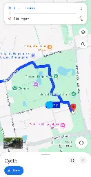
Sanity check on kerb and lit tags
Hello! I've just started using StreetComplete, and I want to make sure I understand the answers before I go through and make a bunch of garbage data.
In this picture, is the kerb a ramp, or flush?
The sidewalk deflects downwards, but it's not a ramp ramp like the example picture.
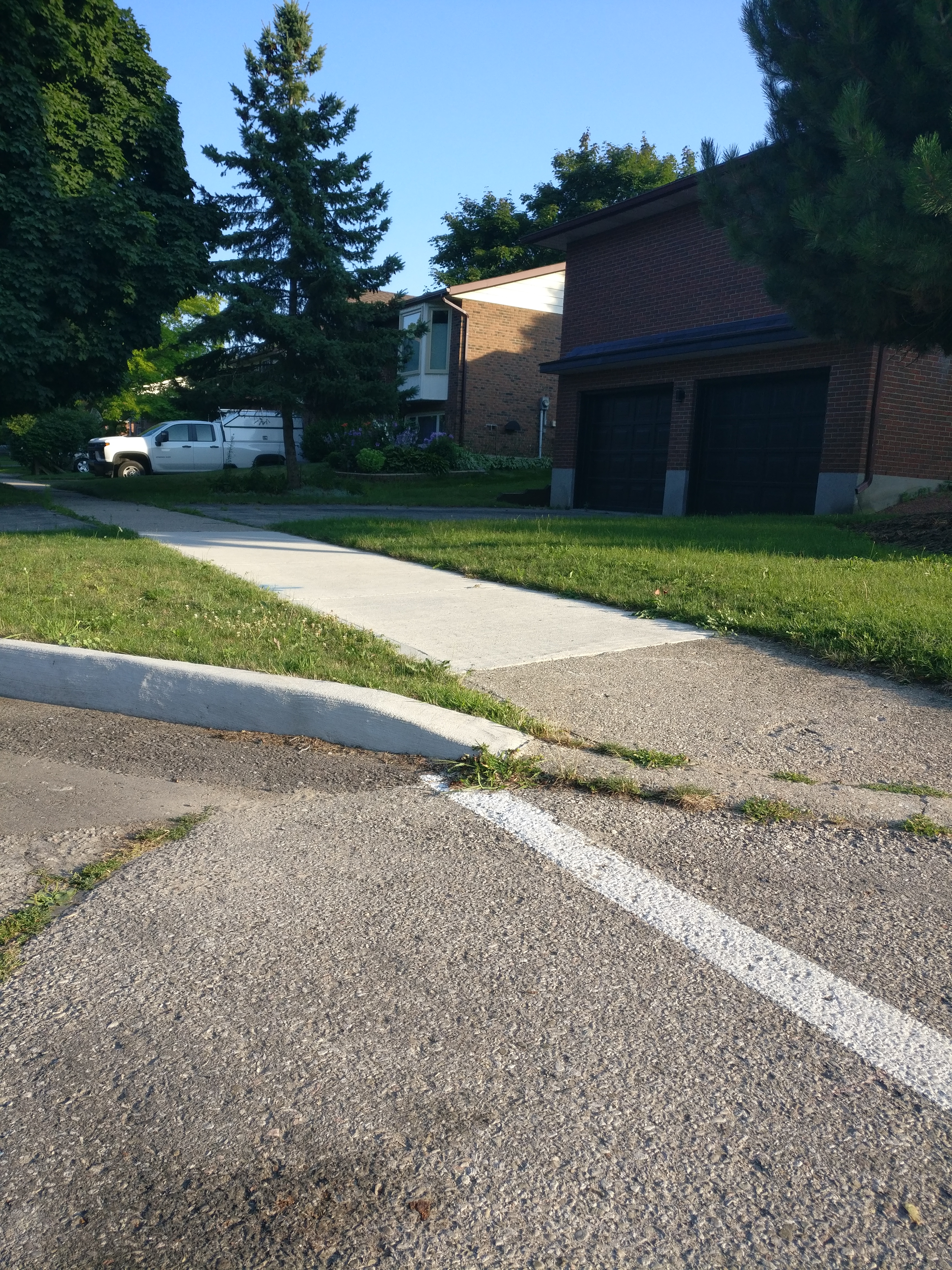
How about this one?
The kerb itself dips, but the sidewalk on this one looks more flat and does simply run into the road. And then it has the texture, obviously. Is this one different from the last one?
Also, just to check, I marked both of these sidewalks as "concrete". That's correct, right? I wondered about "concrete plate", because they're segmented, but the picture made concrete plate look much more substantial.
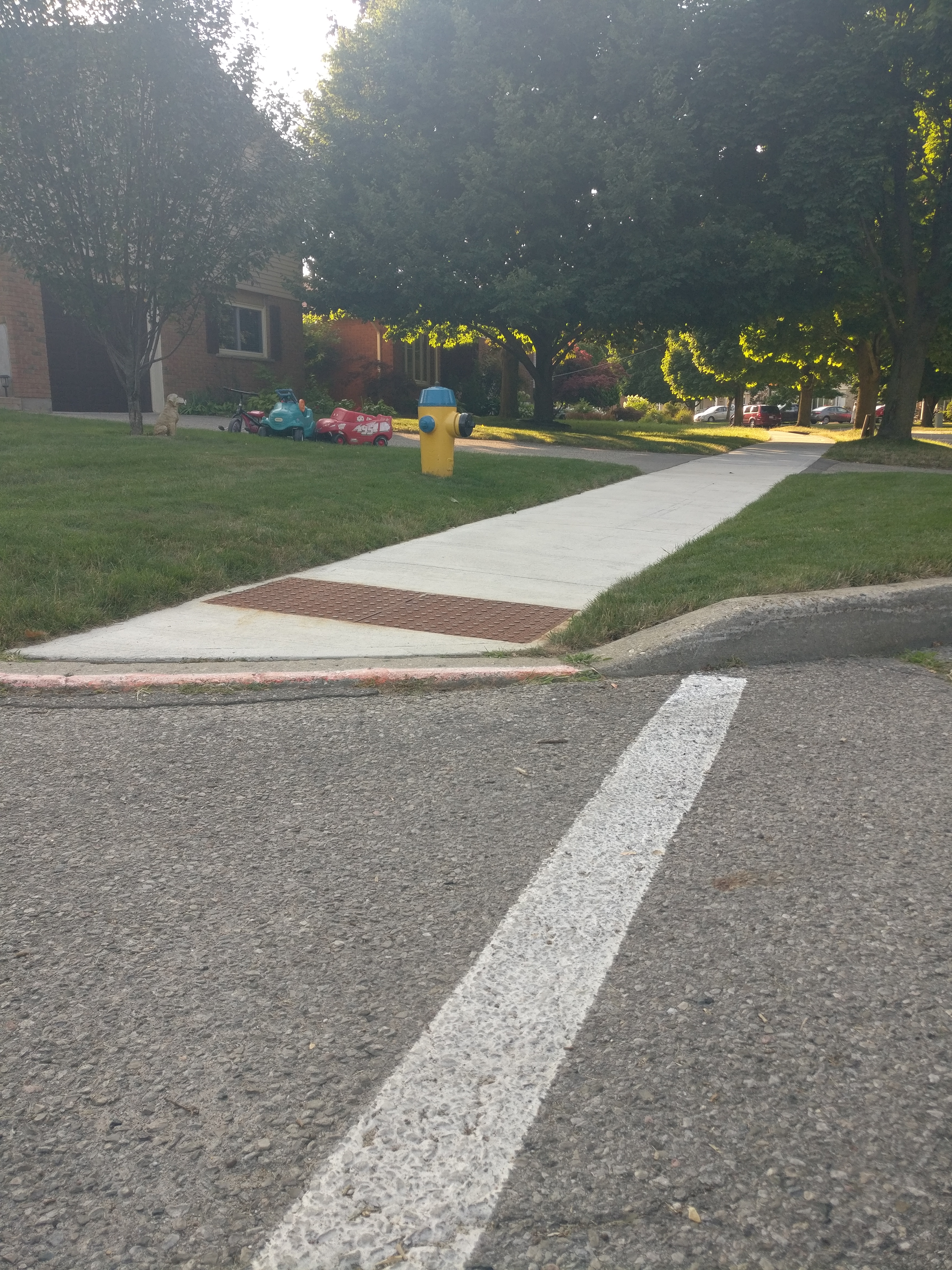
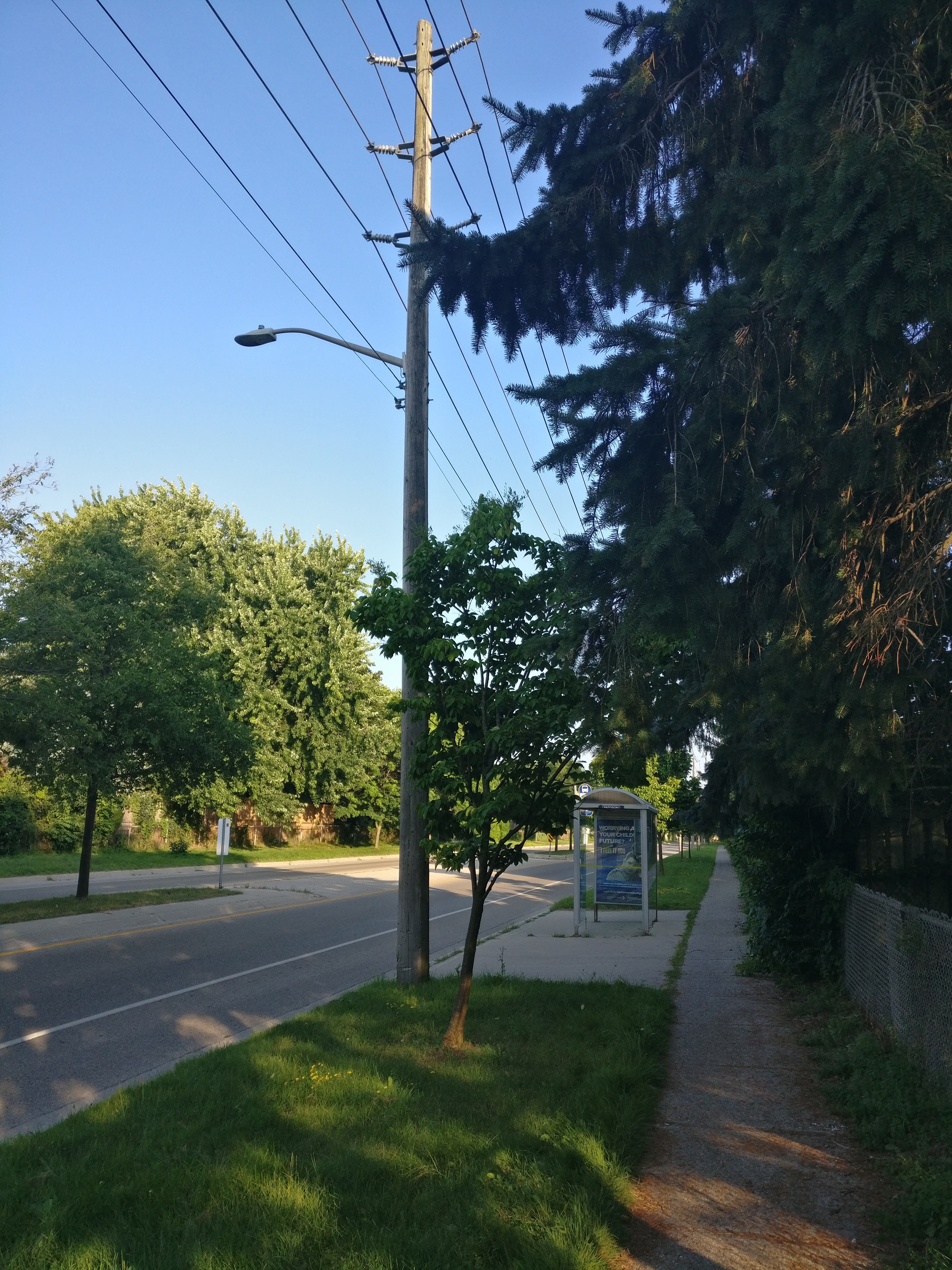
My other question was based on the "lit" tag for a bus stop. This bus stop has a street light near it, but there's no light on the bus stop itself. It sounds like that means it is lit? Would a non-lit stop just be one that is fully dark at night, then, with no kind of lighting anywhere near it at all?
This one is further from the street light, but still has line of sight. Lit?
Thanks very much for any help you have!
Street-Complete, like Pokemon Go but for good.
I first learned of Street-Complete here and I really like it.
It's satisfying to walk around, complete little tasks, and get prizes, scratching a similar itch to Pokemon Go.
Stuck waiting for someone? Add opening hours for a few local businesses.
Have a long walk ahead of you? See if you can add/check house addresses as fast as you can walk.
Want to walk off a few beers before heading home? Complete some tasks in the bar street.
Its a very constructive way to "be right" on the internet.
PSA: OSM is currently down—the Ops Team are working on resolving it
Useful links for tracking this issue:
- Mastodon thread started by @geospacedman
- Mastodon thread started by OSM Ops Team
- Down for Everyone or Just Me
Edit: Viewing and editing functionality seem to be restored.
I need some help .
I need some help @openstreetmap.
UPDATE: Thanks for all the help!
What do I do, if a business has closed down, and then a new business has taken over the same place?
Do I mark the previous business as “does not exist” and add the new one, or do I edit the existing one?
Tag Help
I'm adding a business that is primarily for surfing and also has some skateboard accessories. Can I use multiple tags to designate this?
"shop=surf;skate"
Would that work? On the OSM wiki it says under cuisine you can use multiple tags but I don't see anything saying if it's proper to do that with a key for shop.
Since my last anti-war post (in the broad, global, universal sense; and narrow sense of our project) had been included some comments about the dove, I've created an orthodox version a'la Pablo Picasso
Since my last anti-war post (in the broad, global, universal sense; and narrow sense of our project) had been included some comments about the dove, I've created an orthodox version a'la Pablo Picasso from 1949 😁 Whoever wants it, can use it! (I must say in general that the OSM logo is outstanding in its universality - and this magnifying glass as a symbol of search - sweetness 🍯💪 ). @[email protected] @openstreetmap
OpenStreetMap Community for Peace - logo for free use. @lemmy.ml
OpenStreetMap Community for Peace - logo for free use. @openstreetmap @[email protected]
How would you tag this?
I’m referring to the advertising/digital display. I thought of using man_made=advertising + advertising=* but not of the examples on the wiki seemed to match very well.
EDIT:
I feel like an idiot for missing this but I found advertising=screen (1) after posting this
EDIT 2: Fixed the examples link
Graph widget elevation profile
Edit: the problem is gone, i assume it was a buggy track. The problem exists with the versio 4.7.10, from 24.04.24, which is the version that is recommended by fdroid. It is gone in the latest one from 14.05.24
I updated osmand to 4.7.10 yesterday and now it seems like the little info widget on the bottom screen shows elevation (i assume), relative to the whole track, not the 10km that are currently shown in the widget. Cannot find anything in the settings. In the what's new it said they did some changes to the graphs but i could not make sense of it.
Does anybody know how i can set it back to the way it used to be, as in relative to current section of the track?
We are bringing to #Wikimedia East, Southeast Asia & Pacific (ESEAP) 2024! 🗺️✈️🌏🇲🇾
We are bringing @openstreetmap to #Wikimedia East, Southeast Asia & Pacific (ESEAP) 2024! 🗺️✈️🌏🇲🇾
Join us on Sunday, 12 May, 11AM at Mahua 1 Room to learn how to map in #openstreetmap + link #wikidata!
Full program here: https://meta.wikimedia.org/wiki/ESEAP\_Conference\_2024/Programme
\#eseapconference2024 #ESEAP #ESEAP2024 #ESEAPKK24 #WikimediaESEAP #WikimediaESEAP2024 @seav @Supaplex
Beware of Fake Beaches
Five days ago Niantic announced a new Pokémon in Pokémon Go, which spawns only in beaches. So it could happen that someone could add fake beaches in these days (I found two users already in Italy with a quick check), this is just a reminder to take a look in you local area. One method could be to fi...

Overpass Query:
//courtesy of WoodWoseWulf on Discord [timeout:240] [bbox:{{bbox}}]; ( way[natural=beach](newer:"2024-04-23T00:00:00Z"); ); out body; >; out skel qt;
post has been crossposted since the original did not federate correctly with lemmy.ml
Beware of Fake Beaches
Five days ago Niantic announced a new Pokémon in Pokémon Go, which spawns only in beaches. So it could happen that someone could add fake beaches in these days (I found two users already in Italy with a quick check), this is just a reminder to take a look in you local area. One method could be to fi...
Overpass Query:
//courtesy of WoodWoseWulf on Discord [timeout:240] [bbox:{{bbox}}]; ( way[natural=beach](newer:"2024-04-23T00:00:00Z"); ); out body; >; out skel qt;
EDIT: Added the overpass query from the thread.
@yo_scottie_oh you're right, thank you so much!
There's also this OSM wiki entry that I wasn't able to find before: https://wiki.openstreetmap.org/wiki/Tag:natural=plant
@woelkchen @openstreetmap Odd that this hasn't made it to the main website yet?
@NeatNit @openstreetmap
switching topics again are we?
They rolled out a massive new warning type and then didn't have all their apps accept it as OK. That is a deliberate choice. It is their ecosystem from top to bottom, they *chose* not to have the TetheredNet added to the list of allowed warnings in existing installs. If they hadn't wanted to make that choice they should have done the responsible thing and held the rollout until their app supported it.
I would assume the same as the reason for warning about this in the first place? They don't seem to like devs tying things back to preset websites and think it deserves a massive warning icon.
Maybe, but as it says above, that's the old NonFreeNet complaint that doesn't keep it out of search results.
The newer TetheredNet that is causing it to disappear from in app search results is just that they use their own map servers to serve the map files after they've been converted to the Organic Maps format.
@gedaliyah @NeatNit @openstreetmap
If you select a hotel found on Kayak it will add an affiliate link to Kayak in addition to the direct link stored in OpenStreetMap.
If you know to look in https://gitlab.com/fdroid/fdroiddata/-/blob/master/metadata/app.organicmaps.yml you will find:
"AntiFeatures:
TetheredNet:
en-US: Map download service (cdn*.organicmaps.app).
NonFreeNet:
en-US: Hotel widget includes a link to kayak.com not contained in original map
data."
It's new so I think more will probably be flagged later.
@NeatNit @gedaliyah @openstreetmap
Oh, and they also deliberately buried the rollout of the new anti-feature in the middle of an obscure blog post rather than doing the responsible thing and prompting users to make a decision about it.
https://f-droid.org/2024/04/04/twif.html
@organicmaps is probably on borrowed time before it is also hidden from search.
@NeatNit @gedaliyah @openstreetmap
F-Droid do provide more detail about why they warn that something has an anti-feature, but only make that easily accessible if you run their code natively on your device. If you're on the web interface you have to figure out which of the links in the external links section isn't actually external and look in there.
Their excuse for this is that their website can't parse their own file format that they invented for themselves.
@redd @Tyoda https://mapcomplete.org/trees is mobile friendly and supports the species tag. With plantnet, it even uses AI to automatically detect it!
@InsertUser @openstreetmap A picture to compare.
@InsertUser @openstreetmap @geocaching_de This maps are definitely closer. But still funny 😃.
@Treczoks I agree to that :-)
@inbeesee I'm pretty sure all of Street complete is open source. The team mode is a very clever hack, where each person gets a different number and it's just showing people different quests
@InsertUser @inbeesee the team mode just makes sure 2 people don't gets asked the same thing. Otherwise it's wasted work
@inbeesee @openstreetmap It does have a team mode, but I think that's just a transient thing.
@Tungmar @openstreetmap @geocaching_de
It looks better in the F4 map demo: https://demo.f4map.com/#lat=50.8950203&lon=4.3415218&zoom=18&camera.theta=67.059&camera.phi=-106.857
Streets.gl has an ... interesting interpretation: https://streets.gl/#50.89508,4.34143,45.00,0.00,577.53
@plactagonic
#panoramax (https://panoramax.xyz) offers a federated street-level imagery. Maybe that's what you're looking for? :)
Anyone can contribute on the OSM France instance at https://panoramax.openstreetmap.fr
However, I'm not sure they will accept *videos*.
@Cheradenine If needed, you could try to find someone living elsewhere and share an account