Map Enthusiasts
-
Map of Current and Planned Railways in the Arabian Peninsula
All lines are currently in service except the purple and yellow lines which are under construction. The UAE portion of the Gulf Railway begun freight service and will begin passenger service between Abu Dhabi and Dubai later this year.
The orange line is a dedicated High Speed Rail with a service speed of 300 km/h (190 mph). The remaining line are shared with freight and have a service speed of 200 km/h (120 mph).
-
Map of the Battles of the American Revolution
Please note state lines were disputed as depicted. Notably NH had older claims to the VT territory claimed by NY. And this list isn't all inclusive, there were many small fights.
-
Land Navigation Map Creation
I just recently learned about the website CalTopo and how you can create maps to print out. It's exciting to me because I can create maps based on UTM instead of Lat Long. I have been looking for a solution for a while and am glad to have found this. You can change the scale, the map type, overlays, and more. I had a local store print one on tear and water resistant paper too.
Just wanted to share with the community.
-
The evolution of Paris through historical maps (sources in comment)
A selective superposition of important evolutions of Paris' city limits. Based on this animation video on the evolution of the limits of Paris, from Roman antiquity to present days.
Sources :
- Nicolas Delamare, Traité de la police, Paris, chez J.Cot, 1705 : “Second plan de la ville de Paris” ; “Troisième plan de la ville de Paris”, par Antoine Coquart
- Plan de Truschet et Hoyau, 1553
- Plan de Jean Delagrive, 1728
- Plan d’Alexis Donnet, 1837
- Satellite picture of Paris by Sentinel-2B, ESA, 2018
Most of them are available in very high quality on the David Rumsey cartography center.
-
Greek knowledge of Arabians before Pompey's conquest of Syria (63 BC)
source: https://www.academia.edu/4593009/Arabians_Arabias_and_the_Greeks_Contact_and_Perceptions
-
The Top 20 Planet Wrecker Countries by Expansion Emissions 2023 - 2050
source: https://priceofoil.org/2023/09/12/planet-wreckers-how-20-countries-oil-and-gas-extraction-plans-risk-locking-in-climate-chaos/
- www.manuscriptmaps.com Manuscript Maps — Making Maps : Part 2 - Ink Drawing and Calligraphy
Part 2 of a four-part series in which I explain my map-drawing process, from planning and pencil drawing, to ink and calligraphy, and some weird and wonderful tricks I’ve learned, such as how to fix a mistake!

-
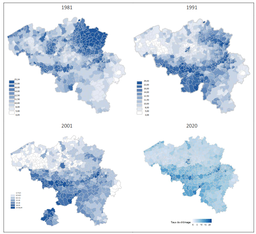
Unemployment rate in Belgium (2020)
In the map it can be clearly seen that the unemployment is higher in Wallonia than in Flanders. This is largely due to the fact that Wallonia has historically relied on its heavy industry, such as steel and coal, which has moved abroad the last decades. In fact, the Sambre and Meuse valley which was the industrial heartland in Belgium thanks to its coal resources, can be clearly seen on the map.
It is also interesting to see how the distribution of unemployment has changed throughout the years, as seen on these maps: !
-
The Alps, hand-drawn in Tolkien's style
Source: https://old.reddit.com/r/MapPorn/comments/1dgewxc/the_alps_handdrawn_by_myself_in_tolkiens_style/
-
Germany: Largest party in 2024 EU elections vs 1947 west/east Germany division
(sorry about the colors not matching)
-
2024 Indian Parliament election results - Maharashtra
Cyan - Congress (13 seats), Green - SSUBT (9), Orange - BJP (9), Pink - NCPSP (8), Yellow - SHS (7), Blue - NCP(AP) (1), Grey - Ind (1)
The shapefile is from the Election Commission of India website.